Sunday, September 10, 2017

Keeping Flexible


“If you can’t get five, take three.” Having been snookered by Harvey, we decided to make the trip back to Virginia into a new trip. So we started working on Plan B. That consisted of a trip to the Great Smoky Mountains NP and thence home via the Blue Ridge Parkway. Along the way we could visit Gene’s brother Mike, and Jean’s friend and old teacher Glen. So we headed east. Just east of Nashville, Harvey started catching up with us. The forecasts had him going a lot of places, many in our projected path. Trying to fit our projections with Harvey’s proved to be difficult and frustrating.
Things seemed very changeable, and we came up with plans C, D, and E. Eventually, Harvey went north and we went back to Plan B.
West of Nashville, the outer bands caught up with us and we ran through occasional rain in varying degrees of intensity, but none heavy. We contacted Gene’s brother Mike who agreed to meet us at the Harriman Cracker Barrel. We got there and parked behind the restaurant, which is the only level place there. After a while we saw the manager come by and look us over, but he didn’t knock on the door. Since we hadn’t formally asked for permission, I was a little worried, so I went out and spoke to him. He was mainly interested in our rig, since he was thinking of getting one. We showed him the inside and made a friend.
Mike came by and we went out to a nearby Mexican restaurant for drinks and dinner. We decided to stay another day, so next day, after breakfast in the restaurant, we drove to Mike’s house. We had avoided doing that at first because the last time we were there, we were parked in a low spot in his driveway and had a very hard time getting the rig leveled. This time we tried a different approach and were able to park level — albeit so close to his garage we couldn’t open the rear doors. Luckily, we didn’t need to. The day was overcast, with occasional light rain. The solar panels didn’t produce much, but the battery held through the night to our great pleasure. We spent the day visiting, and then went out to a different Mexican restaurant for dinner.
Next morning, we visited briefly with Mike and Heidi and their daughter Melissa, then headed for Bristol. Jean needed to get to a Wells Fargo bank and we hadn’t seen one anywhere in Tennessee. Bristol is right on the line between Virginia and Tennessee. In fact, the line goes down the middle of the main street. Driving down the street there is a procession of American and Tennessee flags on one side of the street, and American and Virginia flags on the other. The Wells Fargo was on the Virginia side.
Once her business was finished, we drove to the Medical Center, where Jean’s sister-in-law was in Intensive Care. We caught up with her brother-in-law in the lobby and talked for a while. The sun came out as we were fueling up, so we headed for Asheville, NC. There were still storm clouds as we headed into the Appalachians, which made for great vistas after spending several weeks in the plains.

We managed to contact Jean’s friend Glen, who informed us that the Friday night dances were finished for the year, but there was an event in Asheville the next day. We pulled in to a Cracker Barrel in Asheville for the night. The next day was busy and a little confusing. After breakfast, we went in search of propane. We found a campground that had propane but they wouldn’t sell us any unless we paid for a site (which we didn’t need). We finally found some at a Tractor Supply Company. Then we had to find a Post Office so Jean could mail some bills that were due.
Jean called Glen and got directions to his house. But first, we needed to find a place for the night. Since this was Labor Day weekend, we expected that could be difficult. We tried a KOA near Glen’s house but kept getting busy signals. The only other campground in the area was a place called “Mama Gertie’s.” We tried that and got through to a woman who seemed a little confused. It didn’t sound too promising but we felt we didn’t have much choice. They had one space left, so we took it.
The directions to get there were to take Exit 59, turn right, and go uphill (in fact the address is on Uphill Rd.). So we did and uphill it was. We climbed up the steep side of a mountain, wondering how they could put a campground (which requires level ground) on such a place. When we got there, we continued to go uphill through the campground. The road was steep, but the camp sites were carved into the hill and were level. We climbed through three layers of campers, and finally came out at a level place way up the hill. What with sharp turns and such we wondered whether any big Class A’s could make it but there were several up there. This was obviously a new section and everything was first-class.
View from Mama Gertie's

We finished up our tasks for the day: filling the water tank and dumping the holding tanks. Then we headed back down the mountain to visit Glen. After visiting with Glen and Evelyn for a while, we drove back in to Asheville to find the “Shindig on the Green.” Finding a level parking place in this hilly town took a while, but we got one about two blocks from the event. We met Glen and Evelyn there; he has been associated with the event for years and emceed a little more than half of it.
“Shindig on the Green” consists of a series of acts by local musicians. Stony Creek is sort of the house band. There were two clogging groups as well as a parade of musicians of various ages and abilities. Each musical group played two songs, and then came another. Glen also called a big circle dance with lots of participants.


Supper was barbecue from one of the vendors. There was a threat of rain that didn’t happen; and all-in-all it was a most pleasant evening. All that was left was to climb the mountain back to our campsite in the dark.
Next morning, we were right next to the laundry, so we did a load. That finished just at check-out time, so we packed everything up and went in to Black Mountain for breakfast. Jean used to hang out there in her student days, so she was interested in what it was like now. After breakfast we walked around and went in to a couple of shops. Then it was off to Asheville. The plan was to see Biltmore, then stay at the Cracker Barrel again and head off for Great Smoky National Park on Labor Day (when, with luck, the campground will be emptying out).
The traffic was heavy going in to Biltmore. No surprise there. The surprise came when we went in to buy our tickets. Prices for adults were $75 apiece — holiday special price, normally it is $65. That is way beyond our range, either way. So we watched the little slide show and reluctantly drove back out.
We thought it would be interesting to see downtown Asheville, so we headed that way. Downtown was crowded and there was nowhere we could park. Things were not going according to plan. We gave up and headed toward Cherokee, hoping to find someplace to park along the way. The Allstays app said that the casino in Cherokee allowed RVs to park overnight. Sounded good to us. We made it in to Cherokee in reasonable time and went in to the huge casino parking lot. Mobbed wouldn’t cover it. Nowhere did we see an RV. Looking in the casino book, we found that the Cherokee casino did not allow overnight RV parking. In fact, there is no casino parking anywhere in North Carolina. Our bad luck seemed to be holding.
This being Labor Day weekend in a popular area, we despaired of finding a place to camp. However, one campground right in Cherokee had a space, so we took it. In fact, there seemed to be a couple of empty spaces. We finally caught a break just when we needed it. But our problems were not over. When we went to lower the sofa into a bed, it hung up halfway. It would neither go down nor back up. Gene spent about an hour and a half in the dark messing with it. He has more persistence than mechanical skill, but he finally got it all the way down. So we had a bed to sleep in, but we didn’t dare try to put it up again, so we finished the trip with no sofa.
Next day was Monday, Labor Day. Our next goal was Cades Cove in the Great Smoky Mountains Park, which has a campground. We assumed that the campground would be packed for the holiday weekend, but people would be checking out on Monday afternoon. We took our time getting started, then tanked up on fuel. We left Cherokee about noon and headed for the park. We drove by the Visitor Center (which was crowded) with the idea that we could get a park map when we checked in at the entrance gate. It turns out that Great Smoky NP doesn’t have an entry gate. Soon we were in the park and climbing. Meanwhile, the traffic leaving the park was endless.
We wound up into the mountains with gorgeous views on all sides. The top, at Newfound Gap, is at 5,046 feet, almost 4,000 feet higher than where we started. It is a twisty, mountain road but well worth the effort. All the overlooks were crowded (and the best ones on the wrong side of the road), so we decided to shoot pictures on the way out when it would be better. As is turns out, we went out a different way.
We eventually went in to the Sugarland Visitor Center, on the other side of the park. There we finally got the map, and saw an excellent film about the park. From there we took another twisty (but mostly level) road through the park to Cades Cove. We arrived at the campground about 3:30 and found that our prediction was right. The campground had been completely filled over the weekend, but now he had our choice of sites. We counted twelve other rigs that night.
Next day, Tuesday, we got up early to drive the eleven-mile loop road. We were early in hopes of spotting some wildlife, especially bears. In the event, we saw a few turkeys and one deer. The same things we see all the time on the farm. What we did see were some of the old cabins and farmsteads. The oldest ones were log construction.
Oldest building in the park

After some sawmills were established, there were more plank buildings. There is even one that is half-and-half.

Old sawmill and gist mill

Some of the people had what were called “cantilever barns.”

There are a number of old churches (and their associated graveyards) on the loop.

One that interested Gene was a Baptist church with an apse-shaped end. This is common on European cathedrals, but rare in old American churches.


The weather was overcast with occasional sprinkles. Then, just as we got to the end, the sun came out. So we went around again. This time we had some interesting experiences. One was meeting a car going the other way on this one-lane, one-way road. After the shock, he pulled off the road and we went on.
After seeing a church that we had missed the first time around, we came to the pull-off that has the most gorgeous vista on the whole loop. While we were there a car full of twenty-somethings from New Jersey pulled in. They all got out and draped themselves around the car, and one man stepped out front, turned his back to the view, and took a picture of the car. Having driven hundreds of miles to one of the most beautiful spots in the country, he took a picture that he could have taken in his own driveway. They fooled with the camera for a while, but it didn’t appear that anyone even looked at the scene. Then they drove away.

About half-way through it started raining again, this time pretty hard. As we approached the end of the loop we ran into a long traffic jam. I didn’t realize there were that many cars on the road. We assumed it was a “critter jam” because near the end there were three or four cars pulled off the road and several people at the edge looking at something in the woods. We couldn’t see what they were looking at so we just continued on in the rain. We were soon back in our campsite, setting up in the rain (no hookups, very quick). We spent the rest of the day napping and reading — very laid back.
It rained off and on during the day and overnight. The next day (Wednesday) the forecast was for more rain, but clearing late. Not wanting to drive the mountains in the rain (and possible fog) we bought another night, and relaxed another day. The closest thing to wildlife we saw that day was this tree frog.

Finally, on Thursday we checked out and headed toward home. We needed groceries, so we left the park and went to Pigeon Forge. After stocking up, we headed out of town on the main drag. Traffic was heavy, but there seemed to be a huge car show the length of the street. Parked in the business parking lots was an incredible number of hot rods and old restored cars. There was even an old Bugatti (a type 35 from the 20’s I think)! We kept seeing hot rods on the road for much of the rest of the day.
We took I-40 back to Asheville, where we picked up the Blue Ridge Parkway. It felt good to be off the interstate and back on the quiet road through the mountains. In the late afternoon, we checked in at Crabtree Falls campground. There are no hookups, but that is not usually a problem for us. That night it was. When we set up, we tried switching the refrigerator from DC (which we use while driving) to propane. It would not even try to start on gas. We can’t leave it on DC overnight because it would deplete the battery. What we did was to start the generator so we could run it on AC. But we had to turn the generator off at 9:00pm for quiet hours. We just turned the fridge off and hoped it would hold its temperature enough through the night (which promised to be cold). Then in the morning we could turn the generator on again. It held its temperature well, but did get warm enough to start defrosting the freezer compartment — but not enough to thaw the contents.
Next morning, we dumped our tanks on the way out. Then we went in to Linville Falls Visitor Center to find out a close place to get diesel. Per their advice, we got off the Parkway and went in to the village of Linville. There is a gas station there and it does sell diesel. After waiting for the one pump that also had diesel, we found that they were out. The attendant told us where the next place with diesel was. When we got there, it was a crowded, tiny station with one diesel pump. There were two dump trucks and a flat-bed in line. After waiting a while, I checked the Gas Buddy app and found there was another station selling diesel a few miles further along. We went there, only to find that they were also out of diesel. Gas Buddy had no further ideas, so we went back the previous station. The two dump trucks were gone (after taking on 75 gallons) but there were now two more people in line. So we got in line and waited. The pump was running slow, so it was quite a wait. We finally got our fuel and headed back to the Parkway, but the adventure had taken two hours.
Back on the Parkway, we went to see the Moses Cone mansion. If we can’t see Biltmore this house is fancy enough for us. Inside, there were many locally-made crafts for sale.

Heading north once more we encountered a large number of runners spaced out over several miles. It can be tight encountering a runner at the same time another car is approaching from the opposite direction on a two-lane road.
Toward the end of the day, we spent some time on the phone to various local campgrounds. For one we just got sent to voice mail. On two others, the campgrounds sounded pretty primitive, with unreliable electricity (to run our refrigerator). Jean finally went in to a biker bar (the only establishment available) and got directions to the first campground. It turned out to be convenient and very nice. It had widely spaced campsites with full hookups and the restrooms had tiled showers.
The last day on the road, we drove to the Blue Ridge Music Center, dedicated to mountain music. They have built a small, new building since we were last there. It was labeled the Luther (guitar-builder) building and we got there just at noon, when the live music begins. In fact, one of the musicians was an instrument builder, who played some of his instruments. The five musicians were all local and put on a good show. We stayed through several numbers, but had to move on.
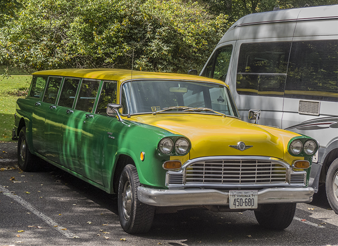
We had lunch at the restaurant at Mabry Mill. In the parking lot we saw a Checker airport limousine. I never knew they made one.

We were getting close to the end now. We pulled off on one more overlook to see the mountains rolling away like waves on the ocean.

After this last view of the mountains, we visited one of Jean’s cousins who lives just off the Parkway until he needed to go to work. We made it home a little after 7:00.
Statistics: We were gone 45 days, during which time we covered 4,932 miles. One trip basically turned into two, so we have half a trip still to do.

Tuesday, August 29, 2017

Pressing On


After the Eclipse we took a side trip to visit a cousin of Jean’s. Thus we crossed the river at Cape Girardeau and instead of continuing south we headed west into the Ozarks. Jean’s cousin, Mike, and his wife, Susan, live on a 320-acre farm. Like us, they don’t farm it; they inherited it from Mike’s parents. It is back in the woods, five miles off the end of the pavement. Driving those five miles on a barely graveled road made me glad I didn’t try the 20 miles into Chaco Canyon. A car on a dirt road is one thing, a motorhome is something else again.
We spent three days visiting. Mostly we just talked. Mike has done extensive family research and filled Jean in on many details she didn’t know about. She also had information that he didn’t, so it was a successful time.

On the third day, Mike took us just across the Arkansas line to Mammoth Hot Springs State Park. The park is small but well-done, with a restored train depot preserved and open to the public.


They have also preserved the original power station at the dam. Compared with today’s power stations, it looks awfully small.


On the way back, he took us through the village of Koshkonong. He told us that it was once one of the richest towns in the Midwest, thanks to shipping huge quantities of peaches. Today it is almost a ghost town. The streets look like they haven’t been repaired in decades, rough and full of big potholes. None of the commercial buildings is occupied except for the Post Office and a Senior Center. A couple of the houses appeared to be occupied, but there was no one on the street, or any traffic. A very sad sight.
Saturday we headed back to the GRR, after Susan, who makes historical clothing professionally, gave Jean a history of corsets — with examples. Then we rolled back down the dirt road we came in on and were soon heading east again. The weather in the Ozarks was most pleasant. Once we got back down on the prairie, the temperature went back up to air-conditioner range.
In the afternoon we crossed back over the Mississippi into Illinois, and were soon in Cairo. Cairo was a big surprise. During the steamboat era it was a major port on the river, at the confluence of the Ohio and the Mississippi. After the Civil War, it was nearly destroyed by racial conflict. Today the population is less than 3,000. It has wide streets with some impressive buildings, both public and private, but no traffic and few people.

The main street in Cairo
Cairo Public Library

Like Portsmouth, there are murals on the (Ohio) river wall.


They concentrate on Cairo’s glory days.


At the bottom of town there is a park which it took us two or three tries to find (and an unwanted trip across the river back to Missouri). It is at the confluence of the Ohio and Mississippi rivers.


There is also a sculpture commemorating the five days that Lewis and Clark spent there gathering their people and teaching them navigational skills, before beginning their epic exploration.


Parked alongside on the Mississippi side was the biggest tow we had seen so far. I could barely get it all in a wide-angle picture.


From there we drove down some beautiful countryside in Kentucky to a state park where we laid over a day to do laundry and catch up with other chores. It’s a beautiful park, with lots of amenities and a view of the river.
All along, we had been getting frequent text messages from Jean’s brother, Chillie, on the hurricane threatening, and then hitting, Texas. On Monday, we headed for the nearest big town, someplace where we could get cell service. We aimed for Jackson, TN. Part way there, at a lunch stop, Gene checked his Allstays app to see what campgrounds might be available in Jackson. He learned that the road we were on (the most direct way to Jackson) had two underpasses with 8-foot clearance. He didn’t even know the app showed that information. So we had to change our route.
Jackson is big enough to have lots of traffic and confusing streets. We wasted a lot of time trying to find a Walmart to do some shopping. We finally gave up and headed to the nearest campground. We found Jackson RV Campground, right at the edge of the city. It looked like an overpriced slum, and we gave up on that one. So far Jackson didn’t seem too welcoming.
Jean found another campground further out. With a name like “Whispering Pines” it held out lots of promise. When we got there it turned out to be small and kind of rough. But the proprietor was friendly and helpful — and it has cable. So we bought two nights. The main object is to watch the storm and make some decisions.
So far, all campgrounds we have been in have had at least bathrooms, often with showers. This one has a building labeled “Laundry.” I went there, expecting it to have a bathroom. It doesn’t, but there is a small room off the laundry portion that has a bathtub! Unique.
But it does have cable. We watched the coverage on the Weather Channel for a long time, then saw the news and some Monday night TV. Our original idea was to wait out the storm and then continue our trip. We are now about half-way down the Mississippi. After some discussion and consulting of maps, we concluded that the rest of the way was going to be a total disaster area. Going down there now, we would only be disaster tourists — not something we would want.
So as of now, we are stopping the trip and heading for home. Not that we will be rushing back. Here in Tennessee, there are other things to see and friends and relatives to visit. Gene has lived in Virginia for more than 50 years and has never been to the Great Smoky Mountains. So we have a new plan for a casual and interesting trip back to Virginia. We are thinking about picking up the rest of the GRR next winter, taking the long way to Florida for our usual visit. Keep tuned.

Wednesday, August 23, 2017

Eclipse


After fueling up and doing our laundry, we headed for the Star View Vineyard. We had made reservations there last November for Sunday night, 20 August. We arrived to find very little level ground. We managed to get a suitable spot with the help of blocks. We were surprised that there was only one other RV there, a pop-up. We had expected more. I had had a piece of heavy filter material drop-shipped to me at the Vineyard. I spent some time that night cutting a filter to fit on my camera. I had also completely charged my battery and bought a new 8Gb card to be used only for the eclipse.

Next morning dawned clear. So far so good. There were a couple of people setting up telescopes on motor-driven mounts with cameras attached behind the pop-up. They had thousands of dollars worth of sophisticated equipment, but one of them had to borrow my Leatherman to make an adjustment. They were out working a couple of hours before the event, which was to start about noon.


The vineyard soon began to fill up with people come to enjoy the event. This contrasts with the attitude of earlier days. There was a total eclipse when Jean was living in Mexico. She and the children got all prepared with their viewing boxes, etc. The local housemaid was frightened and warned them that it was bad luck to be outside during an eclipse. Not all native attitudes were negative. One old story says that there is an old woman weaving a basket. When the basket is completed, the world will come to an end. But periodically a dog, named “Eclipse,” comes along and tears the basket up; so the old woman has to start all over again.

We were parked in the hot sun, so we ran the generator and the air conditioner all day. Meanwhile we took our chairs into the shade of some pine trees, where we were entertained by a couple keeping up with a two-year-old girl. About ten of twelve, I set up in the sun and started  shooting.  Jean came out and watched through solar glasses.


The event takes two-and-a-half hours to complete, so I got comfortable.


About that time, scattered clouds moved in. Also, as the disk of the sun got smaller, the camera began having trouble finding focus.


 During the moments of totality, I needed to take off the filter (and put it on again as the moon moved on). I continued shooting (though most folks left after totality) which allowed me to record the entire event.


At the climactic moment, I got some interesting effects.


As well as more normal pictures.


After resting from our efforts (and mainly the heat) we went in the air-conditioned tasting room and had sandwiches (with wine, of course) . Then we wrapped everything up, bid our hosts fond adieu, and drove back to the Devil’s Backbone. By that time the traffic had died down and it was an easy 34 miles. This event was our one scheduled stop. Tomorrow we make a side trip into Missouri to visit some of Jean’s relatives and then it is back to the Great River Road.

Saturday, August 19, 2017

Iowa and Illinois


Goose Island County Park, just south of La Crosse, is one of our favorite campgrounds. We set up on grass next to a backwater of the Mississippi. We could do some bird watching right from the rig, how lazy can you get? One of our neighbors, a couple of sites down, had a sofa outside next to the fire ring (in which he made a huge blaze). This seems to be a place of comfort.
The sole of Jean’s tennis shoe started peeling off. This is something I can fix, but only at home. So we got directions to the big mall in La Crosse and set off. It was all the way on the other side of the city and there was plenty of traffic, but it was easy to find. Jean went in to Penny’s to look for shoes and I took refuge in Barnes and Noble. I convinced myself that I was doing research by browsing through travel magazines. I discovered a slick RV magazine aimed at Millennials, which I actually bought. I doubt that I can imitate a Millennial, but it is worth a little study.  It took Jean a long time to find a pair of shoes she liked, so I had lots of browsing.
On the way back, we stopped at Walmart for groceries, miscellaneous needs, and prescription refills. By the time all the shopping was finished, the day was almost over. So we went back to Goose Island and managed to get our same campsite for another night. I called my sister for her birthday and we got all caught up.
We stayed up late reading, slept in the next day. We are getting into the slowing-down process. We drove south a short distance, then crossed the river into Iowa. We had never been to Iowa before, so we didn’t know what to expect. Not surprisingly, this part of Iowa looks pretty much like Wisconsin, with bluffs along the river and small towns. Our first stop in Iowa was the Effigy Mounds park. The Indians built mounds all over the eastern part of the country. Some are simple, some are in the shape of birds or bears. Some of them contain burials, but not all. They seemed to be put on top of hills a lot, which is the case with this park. We started hiking up the path behind the Visitor Center, but ran out of steam before we got to the top. Disappointing, but maybe we will get another chance.
South of Effigy Mounds a few miles is Pike’s Peak State Park. This was named by Zebulon Pike before he ever got to Colorado. It is opposite the confluence of the Wisconsin River with the Mississippi and is one of the highest points on the river. It is also the place where Marquette and Joliet first encountered the Mississippi.

We took a short hike to Bridal Veil Falls. It is mostly down-hill on a boardwalk with 197 steps, almost like climbing to the top of a lighthouse. But these steps were spaced apart, a few steps then a short level stretch. Going down wasn’t bad, but we had to rest a couple of times coming back. The falls were attractive, but suffered from a dry spell. Still, worth the effort. We rewarded ourselves with ice cream while we watched the hummingbirds.

Bridal Veil Fall
Someone has put out three hummingbird feeders which have attracted 12-15 hummingbirds (they move too fast to count). They all appeared to be female ruby throats (or perhaps juveniles) since there was not a red throat in sight.
The rest of the afternoon we went in to McGregor to do laundry and get some dinner. The town had been hit by a tornado two weeks earlier. It has been mostly cleaned up and you wouldn’t know it unless you looked up to see the missing and damaged roofs. But that doesn’t explain the many empty stores on the main street. It seems to be struggling.
Next morning I took a picture of the river, and got into a conversation with a group of Amish (or perhaps Mennonites) that were visiting the park. Here the GRR is well-marked. The route takes you through several small towns, away from the interstates and big cities. Some are dying and appear to be falling apart; then once in a while you hit one that appears prosperous and attractive. Guttenburg was one of those. It is a lovely town, with a long downtown opposite a park on the bank of the river. It is a pleasure to drive through such a place.
We got to Dubuque in early afternoon and went to the Mississippi River Museum and Aquarium. This is a large, well done museum that is in two buildings. We went through the one devoted to rivers in general. It is a mixture of displays and large fish tanks replicating various types of rivers. About 4:30 we left, got some groceries, and camped in a county park. The campground was full of vehicles with racing canoes on top. Next morning we hung around to watch the beginning of the race which had a leg next to the campground. We talked for a while with a couple who were racers but not in this race. We also spotted a mink moving around in the rip rap.


The museum tickets were good for two days, so we went back and went through the building devoted to the Mississippi. It includes a wing for the classic Mississippi steamboats, which was very informative and interesting to Gene who likes anything having to do with boats. This building also had aquarium tanks, and some displays in a courtyard that included a small, sternwheel tug that we could go aboard. This tug was powered by diesel.
We wound around through downtown Dubuque and finally got on the River Road south. This part of Iowa is hilly and green, with big fields of corn. The road goes through many small towns. In Bellevue there is a state park with a butterfly garden. The garden is impressive, but nary a butterfly --- too cold? too overcast?

Bellevue Butterfly Garden


Next day, we got some rain in the morning. The land is beginning to flatten out; we’re heading into the prairie. We spent some time in Le Claire, a pretty town with active businesses. The main street has speakers with piped in music. We spent some time at the (misnamed?) Buffalo Bill Museum. It had a room full of Buffalo Bill memorabilia in cases, but the rest of the museum was devoted to Le Claire history. There is a building attached that contains a steamer under restoration. You can go aboard and crawl around. It is fascinating to actually be aboard one, albeit a small tug. The whole lower deck (above the hold) is devoted to machinery, with the boilers, propulsion engines, and several other steam-powered devices. The galley is here also, just a refrigerator, a sink, and some counters and cabinets among the machinery. Everything aboard is powered by steam, including a generator. Electricity was only used for lights (and the refrigerator). This boat was the longest-lived steamboat on the river, lasting 70+ years when the average life expectancy was about 10 years. It was also the last steamer to retire.
We stopped for the night at a Corps of Engineers campground. This is a Class A campground and is very well done, one of the best we have stayed in. We had a great view of the river. Next morning we spotted a tow that we had seen in Le Claire, heading in the other direction. He seemed to get stuck because he stopped, drifted back with the current a short ways, and then powered forward again, farther from the bank.

After breakfast in town, we crossed over into Illinois. We passed through many large corn fields. The river, in broad areas with quiet water by the shore, had acres of plants blooming that we took for water lilies. We found out that they are actually American lotus. They have a potato-like root that was used by the Indians.

American Lotus on the River
We went in to Nauvoo, a town where Gene’s great uncle lived and made blue cheese in the years before the first World War. The town is mostly known for its Mormon inhabitants in the 19th century. There is a big Mormon temple on the hill overlooking the river.


Next day we crossed into Missouri and drove to Hannibal. The day was overcast with occasional rain. The old downtown area is Mark Twain everything. We went into the museum, which has quotes and displays covering every aspect of Twain’s life. We spent a long time watching most of the Ken Burns documentary. The museum connects with several houses: Sam Clemens boyhood home, the “Becky Thatcher House,” Sam’s father’s law office, etc. Outdoors it even has the white fence that Tom Sawyer painted. You can take a selfie in front of a real fence painted by a fictional character.

We walked down by the river. This was the river as seen by young Sam Clemens, though in his time there was a lot more action than someone fishing.

Below Hannibal, the land becomes hilly, with farms in the broad valleys. The road mostly stays away from the river. We got tangled up in the edge of St. Louis, but broke free and found the Golden Eagle ferry. This is a tug-and-barge type of ferry that can handle about a dozen cars.
Golden Eagle ferry

It uses an arrangement I haven’t seen before. The bow of the tug is attached to the barge by a pivot on an arm from the middle of the barge.

When they want to go in the other direction, the tug just pivots around to the other hip. There are no lines involved.


On the Illinois side we had lunch at Kinder’s Restaurant “On and Sometimes In the Mississippi River.” This side of the river has part of the Illinois River and several other streams and backwaters, so we had to make a wide detour to get back on the River Road. We  finally got to Pere Marquette State Park campground. We arrived after hours, and the camp host was “off duty” but there were several sites listed on the sign as first-come-first-served so we drove in and picked a spot.
Next morning the camp host came around and collected the fee. The section south of here reminded me of the Pacific Coast Highway north of Long Beach. The road is right up against the bank of the wide river, with bluffs close on the other side. There is not even the usual railroad track between. Perhaps the prettiest stretch so far.
But it can’t last. In a little while we approached St. Louis and all the industrial area on the Illinois side. We were headed for Cahokia Mounds, the biggest mound site in the country. But first we had to deal with the confusion and fast traffic of the city. Somehow we made it and got to the Mounds about 1:30. We spent most of the hot day in the large and well done Visitor Center.
Cahokia main square with large pyramid

Cahokia developed into the largest and most complex city north of Mexico. By AD ll00 it had a bigger population than London. At its height, the city covered about 4,000 acres and had 120 mounds. The population was about 20,000. The largest mound, called “Monk’s Mound,’ is an earthen pyramid more than 100 feet high and covering about 14 acres. The illustrations make the town look similar to Aztec or Mayan towns, but the raised structures were made of earth rather than stone. 
The city included a circle of poles constituting a solar calendar, now called “Woodhenge.”
Woodhenge on the model
We did get outside and it is truly an impressive sight. I took some pictures, but in one of those horrible moments when you push the wrong button too quickly, I lost all but one fairly puny mound.

However, it is a place that deserves a second visit.
Fleeing south from Cahokia, we were two days from the eclipse and entering the Zone of Totality. We have a paid reservation a few miles ahead for Sunday night, but it was now Friday and we were having a difficult time finding space anywhere. Panic time, everything was full and overpriced. We finally scored a site in a park called Devil’s Backbone. We had to rent for an entire week, of which we may use three days. But that was the best we could do. The park is kind of rough-and-ready, but it has power so we can run the air conditioner (it has gotten very hot) and it is right along the river. The people are nice, too. So tomorrow we head into the Zone of Totality; pray for sunshine.