Friday, April 19, 2019

Heading North


We have seen all the places in Florida we wanted to see this trip. It is time to work our way back home. We still have a number of stops we want to make on the way. One of the first is Ouzts Too. That is a country bar and restaurant in the woods at the beginning of the panhandle. Think Florida cracker bar, and you would be pretty close. We learned about this place last year from other campers. It specializes in fresh oysters, Jean’s favorite. So we had to check it out and were not disappointed.
We arrived on a Sunday afternoon to discover that they have live music on Sunday. The joint was jumping. Cars and motorcycles filled the parking area and spilled over down the road.

 
We plunged in anyway and found that the music was outside. Inside there were tables available.

So Jean got her oysters. I had hoped for mullet, but they were out, so I just had chicken. A pleasant time all around. After eating, we checked in at the nearby campground.
We needed to top up the water and dump the sewage. Next day, while I was dumping, a man asked me the way to Wakulla Springs. I thought that sounded vaguely familiar, so I gave him directions to the area south of the Big Bend where there were a lot of springs. After we left, I discovered that my directions were 100% wrong; Wakulla Springs was just down the road a short distance in the other direction. I became one of the statistics that I claim: that when you ask for directions, half the time they are wrong.
We stayed in a small campground a few miles west of Panama City. Next day, we got to our first beach on the panhandle (we didn’t try Panama City Beach). That is Carrabelle Beach. This is the only beach I know of where the trash cans are bear-proof.


 That is because it is right next to Tate’s Hell State Forest. The weather was overcast, chilly, and windy. There were very few people on the beach.

 We walked a short distance down the beach but didn’t find any shells. However, we were treated to a small pod of dolphins cruising just beyond the breakers.

Our course to the west took us through Mexico Beach. When we passed that way last year, we remarked that it looked like a good place to retire. Then Michael happened. We started seeing destruction at Port St. Joe, ten miles to the east. Mexico Beach wasn’t as destroyed as the reports led us to believe. It was still seriously damaged. There were houses missing, or smashed. There were piles of rubble everywhere. The surrounding forests were heavily damaged, with most of the pines snapped off about ten feet up. This picture is not of the seriously damaged parts.


As an illustration of the fact that hurricanes are circular storms, the trees as we approached were all knocked down in one direction, and several miles later they were all down in the other direction.

We were looking forward to Destin. This is a popular beach because of the incredible white sand. It was a chilly day, so we were able to find parking right at the beach. The first thing we noticed was a row of chairs and umbrellas. These are available for rent.

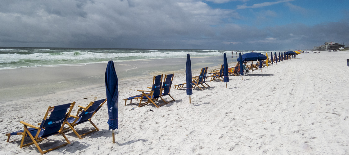
It was a mostly sunny day, with plenty of wind. There were several people out, but probably not as many as if it were warmer. Looking down the beach, you can see the mist blown off the Gulf by the wind.


We walked a way down the beach. We found no shells, just cigarette butts and assorted trash, as well as two dead birds. There were a few shore birds, but not many. Perhaps the popularity of the beach with people keeps them away.


We had looked forward to this beach, so we were quite disappointed. This is a very popular area, as shown by the big condos along the beach road.


We ended up walking along the boardwalk instead. At the end of the boardwalk, Jean spotted something out in the water (there were no people in the water). I managed to get a picture of it, but we have no idea what it is.


So we pressed on, out of Florida. On the way out, I managed to get an appointment with the Mercedes Benz dealer in Pensacola. I had been getting a persistent “High Oil” warning light and I wanted them to look at it.
We had another person to visit. Jean‘s old friend Helen lives in Foley, just across the line in Alabama. We spent the night in a campground in Foley, and connected with her the next morning. After lunch, I took the rig in to Pensacola. The people at Mercedes were able to pull out about a quart-and-a-half of excess oil. I will have to have a conversation with the people who do my oil changes.
Then back to Foley to the Walmart to have a couple of prescriptions filled. There was some confusion, and it took most of the rest of the afternoon, but it eventually got straightened out.
The next day, Helen took us to a couple of local attractions. Foley has a nice town square.

 In the square is a building that houses an amazing model train layout.

 
Gene, being the big kid that he is, was fascinated. They were running several different trains, including a Tommy the Tank Engine.


Gene was fascinated by a long steam engine that had two sets of drivers — articulated to ease it around bends.

In the middle they have a small, turn-of-the-century, Midwestern town. It is complete with a town park that has a tiny model train of its own running around in it.


Some drama is added by having a fire in the fireworks factory.
        

They even have a woods with a still set up in it. They tell the story that the owner of the still brought in a bear to protect it. Here the bear has treed a “revinooer.”


Our next stop was a local history museum, that Helen hadn’t seen yet. There she ran into an old friend. The museum is very large with an extensive collection. Part of the fun of such a place for us old folks is seeing familiar objects that we haven’t seen in years (and maybe owned once). Following that I was prevailed upon to get a haircut. Then back to the apartment, where we had supper and talked and watched television until it was cool enough to go out to the motorhome, where we didn’t have power to run the air conditioner.
Next morning, we headed west for Natchez. Hiway 98, which we had been on since the Big Bend in Florida, runs straight through mostly flat (at first) country. What few towns there are seem to be off the main road. Hattiesburg was the biggest town, and we only got the edge of that.
Jean got us a camp site at a state park by a lake. There were signs that said “Beware of Alligator.” It was quite warm, but since we were hooked up to electricity, we could run the air conditioning. It was quite chilly by morning.
Next day (Saturday — we lose track sometimes) it was very windy, cold, and with occasional rain. It cleared somewhat as we approached Natchez. Eventually we found the excellent Visitor’s Center. They provided us with good information and materials. They even told us where we could get propane nearby. We spent some time watching the weather channel on television. We were in the path of a cold front, with strong winds, rain, and possible tornadoes. The Visitor’s Center provides overnight parking for RVs — with electricity. The parking was a somewhat off level, but you can’t beat the price. In fact, we were most appreciative, not being eager to find a campground on a Saturday in bad weather. One of the other campers learned that the area has very loud tornado sirens, and that the bathrooms in the substantial building would not be closed in case the sirens went off.
No tornadoes, and by morning things had calmed down a little (still cold and some wind). We got information on where to get a hot breakfast, and headed out. After breakfast, we topped up the fuel, got a few essentials at a Walmart, and were ready for the Natchez Trace by noon.
The Natchez Trace is an ancient trail through Mississippi, Alabama, and Tennessee. Farmers in the Kentucky and Ohio area would send their produce and goods down the rivers to Natchez and New Orleans by flatboat. Then they would sell both cargo and boat, and walk back home along the Trace. These travelers were called “Kaintucks,” whether they came from Kentucky or not.


The Natchez Trace Parkway is a beautiful drive, even on a cold, overcast day. The road is smooth and level, and winds through lush woods. Occasionally, a farm butts up next to the road, but otherwise it doesn’t look too different from when it was in the main route up the east side of the Mississippi’
We stopped at several points of interest. Mount Locust Inn and Plantation is the first place a traveler would come to after leaving Natchez. It is the only surviving “stand,” or traveler accommodation on the old route. It was a cotton plantation that also provided shelter for travelers on the Trace.

It looks very inviting to relax on the veranda.
A

Going back to a much earlier time, we took a short side trip to see Emerald Mound. This is the second largest Indian mound in the country. Only the Monk’s Mound, in Cahokia, IL, is bigger, (and it is bigger than the pyramids in Egypt).


It becomes very impressive when you climb it and look down on the motorhome below. We also walked through the Sunken Trace, a place where the heavy traffic wore the path down below grade. It was rough and muddy, a good example of the kind of place travelers had to deal with.
Toward the end of the afternoon, we followed the guide we got in Natchez to a campground in Clinton, MS, at about milepost 89, to finish the first day on the Trace, happy and content.
We needed to do laundry and other tasks, so we spent the day in Clinton. We had some time so we went to see downtown Clinton. It is a typical small Southern town, with brick streets and brick and stone sidewalks.


There are several bicycles mounted beside the road like sculptures.

After walking around downtown, we went in to an antique store to look around. This place turned out to be like a maze. You go into a small room and look around. Then there is a door to another small room, which has a door to another room, until it seemed like it would never end.
Back on the Trace, there was some traffic around Jackson, but things eventually settled down again. For the most part, the Natchez Trace Parkway consisted of a smooth road winding among trees and meadows. Since it was spring, the wide shoulders were often blanketed in wildflowers, blue, yellow, and crimson. In the southern part we also saw a lot of thistle.
The Parkway follows roughly the route of the original Trace. From time to time, sections of the Old Trace are accessible from parkway pull-offs.


At one point the trace passes thirteen graves of unknown Confederate soldiers. The grave stones are all covered in coins, mostly pennies. We have no idea why, but all the gravestones were so covered.


Travelers on the Trace had to deal with a wide range of conditions. They didn’t have the advantage of board walkways through the swamps.

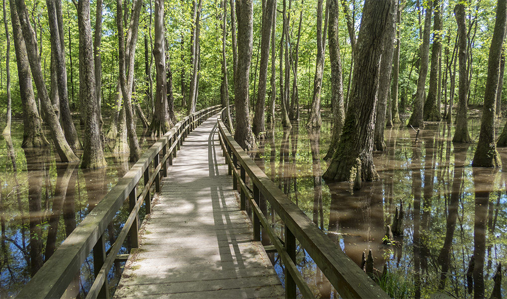
Here in Mississippi we saw more alligators than we did in Florida.

As the parkway continues north, it gets into hilly country, eventually approaching the Appalachian Mountains. Near the north end is the site of Merriwether Lewis’ grave and monument. He was on his way to Washington to edit the journals of the famous trip. He stopped at Grinder’s stand for the night. During the night, people heard two gunshots, and found his body. It has never been determined whether he was murdered or committed suicide (he was dealing with lots of problems).


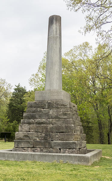
Someone had stuck a tiny toy in the monument


We continued on after the Lewis monument, but that is near the northern end of the parkway. After three days on the parkway, we left two miles before then end, and got on the road to Gene’s brother’s house in eastern Tennessee. The weather forecast for the last, short leg home is really ugly, so we will hunker down for a day. Presumably, we will have good weather for the ride home tomorrow. That will finish a trip of forty days, and about 3800 miles. Time to settle down for a while.

Saturday, April 6, 2019

Florida Circuit


We decided to leave on Thursday. It was a short trip. We hung around the house for a while, then went to the corner service station for fuel. There we met a couple of Florida’s less-friendly natives. Then to the Publix to get a few supplies and find a UPS for Jean to send a fax. That done, we put the campground that Jean and Anna had gone to the day before (and reserved a space) into the GPS. Anna had found the place, but it was part of a day of driving around; we didn’t know how to get there from the Publix, and so the GPS. It was surprisingly empty, though the women had been told that it would be full by the weekend.
This was our problem. We were still in Florida’s high season, and it may or may not have been Spring Break time (we never know when that occurs). With the weekend coming up, it was going to be difficult to find space at a campground. Some people, like my brother, have all the campgrounds reserved (and often paid for) months in advance. But we don’t follow any schedule, and often change plans along the way. This could be a problem in the coming days.
The campground was a Corps of Engineers campground (always very nice), so it was alongside a lock on the canal from the St. Lucie River to Lake Okeechobee. Our site was right along the canal.


 Friday we needed to head on, but we waited to watch a couple of yachts lock through.

 It was a mostly sunny day, with some wind and a few clouds, so we decided to go back to Hobe Sound beach. That was one I was convinced we could easily find. Along the way, we stopped at a McDonald’s for a late breakfast. Parked next door was a shiny, new Model T. It was, as far as I could tell, a kit car. It looked, and sounded, authentic to me.

 We also stopped at a Publix and got some new books to read (I got the latest Wooden Boat magazine). The road to the beach is like driving through a tunnel of banyans.

The beach was cool and windy, though not as much as the day before. The beach here is a dark grey sand, I gathered some for my collection. We didn’t set up chairs, just walked along the beach and collected shells and a couple of pieces of driftwood. Jean is starting to think about a display of some sort.


After that pleasant respite, we plunged into the madness of the Florida Turnpike. It’s about 135 miles to the Everglades, and from here it is almost all city traffic. Might as well get it over with as quickly as possible. There were several backups due to congestion, so it took most of the rest of the afternoon.
About 3:30 or so, Jean started contacting campgrounds. Friday and Saturday are the worst times to find a space at a campground, since they usually fill up for the weekend. She wasn’t having much luck. We would have preferred one of the campgrounds in the park itself, but we assumed that they would be fully booked. Jean called anyway, just to say we’d covered all the ground. To our delight, she scored two nights. We were even given our choice of campgrounds. We chose Flamingo because it provides electricity and we might need to use the air conditioner. Especially since the overhead vent fan stopped working again a couple of days after the technician fixed it.
It appears the busy season for the Everglades was over for this year. The spaces are large, the day was warm but not hot, and there was a breeze (no mosquitos!). We were set up and relaxing with our Cuba Librés by 6:00 o’clock.
Saturday, we relaxed after breakfast and watched a great egret walking around near the van.

Then we drove the mile or so back to Flamingo. We parked under the trees and observed a pair of ospreys circling and calling. They flew away, but we could still hear osprey calls from nearby. We took a few steps into the grass and looked up. There was an osprey nest in the tree, with three half-grown chicks sitting on the edge 


One of them looked like he was getting his courage up to try flying.


We watched for a while as they encouraged each other, but then we pressed on for the Visitor Center. There we learned that the interesting trees with the big nutlike things in the top are West Indian Mahogany.

We talked with the folks for a while, bought a field guide to SE Florida birds, and headed toward the marina. The main building for the park had been damaged in a couple of hurricanes, and was being restored. But the marina area was still in good shape. Along the way there were several people watching (or trying to watch) two or three manatees cavorting near shore. Unfortunately, they were stirring up so much mud that the water was opaque and you could only see a part of them when it broke the surface.
At the marina, we bought some lunch and a cold drink. We ate it next to the canal, where we watched the goings on of the (other) tourists. There was a crocodile hanging out on the other side of the canal.


Meanwhile the canal itself was a hive of activity with people in rented canoes and kayaks.
           

It’s not Florida without pelicans.


After relaxing for a while, we wandered back to the van. When we got there we saw that the osprey nest was empty. They had all screwed up their courage and had taken off. We wish them good luck and good fishing.
Before we got into the van, several red-bellied woodpeckers flew into the tree in front of us and briefly worked it. Must not have been very good pickings, because the soon flew on.


We drove back to the campground, turned on the air conditioning, and spent the rest of the rest of the afternoon being lazy.

Next morning, we headed out. The Everglades are called a “river of grass.” That describes the sawgrass prairie which is most of it. Basically it was originally a river, 50 miles wide and only a few inches deep that flowed from Lake Okeechobe to Florida Bay. That was covered in sawgrass.


But there are other areas. Higher ground (even if only a couple of feet) are called “hammocks” and create a different environment. There are trees and varied undergrowth. There is a limestone ridge that runs through the ‘glades. This is in places broken into islands, called “keys.” We walked out on Long Pine Key. It is a pine forest, with occasional holes in the limestone caused by acidic water.


On the way out, we stopped by a lake, where we saw our first alligator for this trip.
 
There were also a couple more birds.


Since it was Sunday, we figured we would have a better time finding a campground. The only traffic of any note we found (considering it was a Sunday afternoon) was in beautiful downtown Homestead. Much of the drive was on the Tamiami Trail (US-41). This is a highway cut right through the Everglades. It traverses Big Cyprus National Preserve, and has a canal running alongside it for the entire preserve.
There are Mikossuke Indian villages from time to time. We stopped for lunch at a Mikossuke Restaurant. Expensive, but pleasant eating outside next to the canal. There was a female boat-tailed grackle busily working the tables. While we waited for our food, I made contact with the campground at Collier-Seminole State Park, where we have stayed in the past. I found that they had space available, but they don’t take reservations. We got there about 4:30 and got a site for two nights. We didn’t set up, we just planted our flag and headed out for the local Walmart. We got some needed groceries, and filled up the fuel tank for the first time since we left Stuart, 350 miles ago. All told, a successful day.

We ran out of water in the evening. Luckily, we still had some bottled water left over from when we were winterized. So first thing in the morning, I set up and refilled the water tank. That meant that the holding tanks were probably full, so we dumped on our way out of the park. Then began a long search for breakfast. We usually have breakfast in the rig. When we decide to have breakfast on the road it always seems to take a long time to find a restaurant. Such was the case today.
After we finally got something to eat, we needed to get some groceries. We went in to a handy Walmart and Jean went in for a few groceries while I tried to figure out why her phone didn’t charge last night. The fuse box in the Mercedes is an exercise in frustration on a large scale. The fuse that covered the outlet where the charger was plugged in is the hardest one to get to. Before I attempted that, I got out the multi-tester and learned to my relief that the outlet had power. Obviously, the charger was no longer operating. No problem, here we are at a Walmart. After much searching (where is an employee when you want one?) I found the phone chargers, but the selection was very limited. The same was true in the grocery section. I picked what seemed like the best available charger and went back to the rig. It was the wrong kind. They also didn’t have all the groceries we wanted. We had never seen such an inadequate Walmart.
We eventually came to a mall, where we went inside and found a cell phone place that had the right charger (at a much higher price) and finally got her phone to charge. All told, we got most of what we needed and still made it to Koreshan State Park by 3:30. We got checked in and did laundry.
We spotted these flowers there. We don’t have any idea what they are.


There were also butterflies.


After breakfast in the rig (no orange juice because Walmart didn’t have the kind we need) we headed out for Sanibel Island for another beach day. It turned out to be farther than we had calculated, but we eventually found our way there. The main road up the island was bumper to bumper (no surprise) and we crawled a long way up the island without finding any signs for the beach. So we found a road closer to the water, and worked our way back. We eventually worked our way back to the lighthouse, at the beginning of the island. There we found parking, and even an empty spot in the space set aside for RVs.


The beach was only moderately crowded. There were a couple of people trying to kite sail, but I guess the wind was not strong enough to pull them up. A big, high-speed tour boat came by just offshore.


After an hour and a half, we both had about as much sun and heat as we could take and headed back, looking for some lunch. We shopped for a bit in the oldest shop on the island; small but interesting, as was the old guy running it. On the way back to the campground, we stopped at a Publix and got the stuff we couldn’t find at the Walmart.
A couple of nights ago we ran out of water. This night we didn’t have power to the outlet over the counter. Again, I spent some time checking things out. I finally found that the convertor-inverter under the driver’s seat had kicked off. So we didn’t have any power to the outlets served by the inverter — and the house battery was not being charged. I reset the unit and we had power back to the outlet, but it took quite a while to get the house battery fully charged.

Next day (Thursday) we headed up US 41. That led us through Ft. Meyers, Venice, Sarasota, and Bradenton. All areas with heavy traffic. During the afternoon, Jean contacted Manatee State Park and learned that they had a space available, but it was first come, first served only. That made the struggle with the traffic even more frustrating. We did manage to make it to the park about 30 miles east of Bradenton in time and got another spot in the jungle.


One of the things I find fascinating about Florida, is the variety of trees, including some that look like they were designed by Dr. Seuss.


Jean contacted her sister-in-law, Chris, and we arranged to see her next day at her home in Seffner, east of Tampa. We had a very nice visit, then after lunch the women went shopping, another of Jean’s favorite things. We finished off the day with strawberry shortcake, even though the Strawberry Festival is over.

Next day, Saturday, it was time to head out again. Jean loves the Sponge Docks area of Tarpon Springs, so that was our destination. We took a wide swing around Tampa. We probably drove farther and longer than a more direct route, but the traffic was less and the scenery better. Tarpon Springs on a nice Saturday is tourist central. We found a spot on the parking lot for a popular restaurant, which solved the problem of where we would have lunch. First, we walked around a little and went into a couple of shops. There was an older, wooden sailboat tied up at the bulkhead. It is not clear if it is an example of an older sponge-fishing boat. I took a picture of it anyway because I love old wooden sailboats.

Next to the boat is a statue of a hard-hat sponge diver. That is the business that made Tarpon Springs famous.


We managed to contact a campground that had a space on a Saturday at a less than outrageous price. (Not a lot less, but less than the others.) Then we went to the Greek restaurant to have our lunch and get a parking pass. This was the second place we have seen that puts its Greek salad on a scoop of potato salad. We decided to eat something else.
In the middle of the hot afternoon, we headed out to find our campsite. We drove through pleasant residential areas, followed by industrial areas, followed by country. We arrived at this old, overgrown campground in the middle of the jungle. It had seen better days, but the utilities all worked, so we hooked up and turned on the air conditioning.

This marks our turn. From here, every day brings us loser to home.  We hope that by the time we get there, it will have warmed up a bit.