
The sole of Jean’s tennis shoe
started peeling off. This is something I can fix, but only at home. So we got directions
to the big mall in La Crosse and set off. It was all the way on the other side
of the city and there was plenty of traffic, but it was easy to find. Jean went
in to Penny’s to look for shoes and I took refuge in Barnes and Noble. I
convinced myself that I was doing research by browsing through travel
magazines. I discovered a slick RV magazine aimed at Millennials, which I
actually bought. I doubt that I can imitate a Millennial, but it is worth a
little study. It took Jean a long time
to find a pair of shoes she liked, so I had lots of browsing.
On the way back, we stopped at
Walmart for groceries, miscellaneous needs, and prescription refills. By the
time all the shopping was finished, the day was almost over. So we went back to
Goose Island and managed to get our same campsite for another night. I called
my sister for her birthday and we got all caught up.
We stayed up late reading, slept
in the next day. We are getting into the slowing-down process. We drove south a
short distance, then crossed the river into Iowa. We had never been to Iowa
before, so we didn’t know what to expect. Not surprisingly, this part of Iowa
looks pretty much like Wisconsin, with bluffs along the river and small towns.
Our first stop in Iowa was the Effigy Mounds park. The Indians built mounds all
over the eastern part of the country. Some are simple, some are in the shape of
birds or bears. Some of them contain burials, but not all. They seemed to be
put on top of hills a lot, which is the case with this park. We started hiking
up the path behind the Visitor Center, but ran out of steam before we got to
the top. Disappointing, but maybe we will get another chance.
South of Effigy Mounds a few
miles is Pike’s Peak State Park. This was named by Zebulon Pike before he ever got
to Colorado. It is opposite the confluence of the Wisconsin River with the
Mississippi and is one of the highest points on the river. It is also the place
where Marquette and Joliet first encountered the Mississippi.

We took a short hike to Bridal
Veil Falls. It is mostly down-hill on a boardwalk with 197 steps, almost like
climbing to the top of a lighthouse. But these steps were spaced apart, a few
steps then a short level stretch. Going down wasn’t bad, but we had to rest a
couple of times coming back. The falls were attractive, but suffered from a dry
spell. Still, worth the effort. We rewarded ourselves with ice cream while we
watched the hummingbirds.
 |
| Bridal Veil Fall |
Someone has put out three
hummingbird feeders which have attracted 12-15 hummingbirds (they move too fast
to count). They all appeared to be female ruby throats (or perhaps juveniles)
since there was not a red throat in sight.
The rest of the afternoon we
went in to McGregor to do laundry and get some dinner. The town had been hit by
a tornado two weeks earlier. It has been mostly cleaned up and you wouldn’t
know it unless you looked up to see the missing and damaged roofs. But that
doesn’t explain the many empty stores on the main street. It seems to be
struggling.
Next morning I took a picture of
the river, and got into a conversation with a group of Amish (or perhaps
Mennonites) that were visiting the park. Here the GRR is well-marked. The route
takes you through several small towns, away from the interstates and big
cities. Some are dying and appear to be falling apart; then once in a while you
hit one that appears prosperous and attractive. Guttenburg was one of those. It
is a lovely town, with a long downtown opposite a park on the bank of the
river. It is a pleasure to drive through such a place.
We got to Dubuque in early
afternoon and went to the Mississippi River Museum and Aquarium. This is a
large, well done museum that is in two buildings. We went through the one
devoted to rivers in general. It is a mixture of displays and large fish tanks
replicating various types of rivers. About 4:30 we left, got some groceries,
and camped in a county park. The campground was full of vehicles with racing
canoes on top. Next morning we hung around to watch the beginning of the race which
had a leg next to the campground. We talked for a while with a couple who were
racers but not in this race. We also spotted a mink moving around in the rip rap.

The museum tickets were good for
two days, so we went back and went through the building devoted to the
Mississippi. It includes a wing for the classic Mississippi steamboats, which
was very informative and interesting to Gene who likes anything having to do
with boats. This building also had aquarium tanks, and some displays in a
courtyard that included a small, sternwheel tug that we could go aboard. This
tug was powered by diesel.
We wound around through downtown
Dubuque and finally got on the River Road south. This part of Iowa is hilly and
green, with big fields of corn. The road goes through many small towns. In Bellevue
there is a state park with a butterfly garden. The garden is impressive, but
nary a butterfly --- too cold? too overcast?
 | |
| Bellevue Butterfly Garden |
Next day, we got some rain in
the morning. The land is beginning to flatten out; we’re heading into the
prairie. We spent some time in Le Claire, a pretty town with active businesses.
The main street has speakers with piped in music. We spent some time at the
(misnamed?) Buffalo Bill Museum. It had a room full of Buffalo Bill memorabilia
in cases, but the rest of the museum was devoted to Le Claire history. There is
a building attached that contains a steamer under restoration. You can go
aboard and crawl around. It is fascinating to actually be aboard one, albeit a
small tug. The whole lower deck (above the hold) is devoted to machinery, with
the boilers, propulsion engines, and several other steam-powered devices. The
galley is here also, just a refrigerator, a sink, and some counters and
cabinets among the machinery. Everything aboard is powered by steam, including
a generator. Electricity was only used for lights (and the refrigerator). This
boat was the longest-lived steamboat on the river, lasting 70+ years when the
average life expectancy was about 10 years. It was also the last steamer to
retire.
We stopped for the night at a Corps
of Engineers campground. This is a Class A campground and is very well done,
one of the best we have stayed in. We had a great view of the river. Next
morning we spotted a tow that we had seen in Le Claire, heading in the other
direction. He seemed to get stuck because he stopped, drifted back with the
current a short ways, and then powered forward again, farther from the bank.

After breakfast in town, we crossed
over into Illinois. We passed through many large corn fields. The river, in
broad areas with quiet water by the shore, had acres of plants blooming that we
took for water lilies. We found out that they are actually American lotus. They
have a potato-like root that was used by the Indians.
 |
| American Lotus on the River |
We went in to Nauvoo, a town
where Gene’s great uncle lived and made blue cheese in the years before the
first World War. The town is mostly known for its Mormon inhabitants in the 19th
century. There is a big Mormon temple on the hill overlooking the river.

Next day we crossed into
Missouri and drove to Hannibal. The day was overcast with occasional rain. The
old downtown area is Mark Twain everything. We went into the museum, which has
quotes and displays covering every aspect of Twain’s life. We spent a long time
watching most of the Ken Burns documentary. The museum connects with several
houses: Sam Clemens boyhood home, the “Becky Thatcher House,” Sam’s father’s
law office, etc. Outdoors it even has the white fence that Tom Sawyer painted.
You can take a selfie in front of a real fence painted by a fictional character.

We walked down by the river.
This was the river as seen by young Sam Clemens, though in his time there was
a lot more action than someone fishing.

Below Hannibal, the land becomes
hilly, with farms in the broad valleys. The road mostly stays away from the
river. We got tangled up in the edge of St. Louis, but broke free and found the
Golden Eagle ferry. This is a tug-and-barge type of ferry that can handle about
a dozen cars.
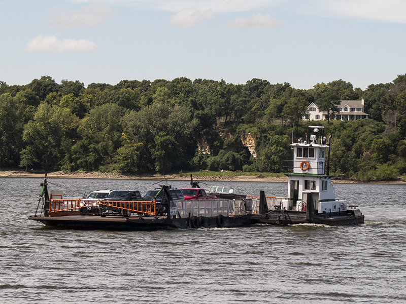 | |
| Golden Eagle ferry |
It uses an arrangement I haven’t
seen before. The bow of the tug is attached to the barge by a pivot on an arm
from the middle of the barge.

When they want to go in the
other direction, the tug just pivots around to the other hip. There are no
lines involved.


On the Illinois side we had
lunch at Kinder’s Restaurant “On and Sometimes In the Mississippi River.” This
side of the river has part of the Illinois River and several other streams and
backwaters, so we had to make a wide detour to get back on the River Road. We finally got to Pere Marquette State Park
campground. We arrived after hours, and the camp host was “off duty” but there
were several sites listed on the sign as first-come-first-served so we drove in
and picked a spot.
Next morning the camp host came
around and collected the fee. The section south of here reminded me of the
Pacific Coast Highway north of Long Beach. The road is right up against the
bank of the wide river, with bluffs close on the other side. There is not even
the usual railroad track between. Perhaps the prettiest stretch so far.
But it can’t last. In a little
while we approached St. Louis and all the industrial area on the Illinois side.
We were headed for Cahokia Mounds, the biggest mound site in the country. But
first we had to deal with the confusion and fast traffic of the city. Somehow
we made it and got to the Mounds about 1:30. We spent most of the hot day in
the large and well done Visitor Center.
 |
| Cahokia main square with large pyramid |
Cahokia developed into the
largest and most complex city north of Mexico. By AD ll00 it had a bigger
population than London. At its height, the city covered about 4,000 acres and
had 120 mounds. The population was about 20,000. The largest mound, called “Monk’s
Mound,’ is an earthen pyramid more than 100 feet high and covering about 14
acres. The illustrations make the town look similar to Aztec or Mayan towns,
but the raised structures were made of earth rather than stone.
The city included a circle of poles
constituting a solar calendar, now called “Woodhenge.”
 |
| Woodhenge on the model |
We did get outside and it is
truly an impressive sight. I took some pictures, but in one of those horrible
moments when you push the wrong button too quickly, I lost all but one fairly
puny mound.

However, it is a place that
deserves a second visit.
Fleeing south from Cahokia, we
were two days from the eclipse and entering the Zone of Totality. We have a
paid reservation a few miles ahead for Sunday night, but it was now Friday and
we were having a difficult time finding space anywhere. Panic time, everything
was full and overpriced. We finally scored a site in a park called Devil’s
Backbone. We had to rent for an entire week, of which we may use three days.
But that was the best we could do. The park is kind of rough-and-ready, but it
has power so we can run the air conditioner (it has gotten very hot) and it is
right along the river. The people are nice, too. So tomorrow we head into the
Zone of Totality; pray for sunshine.
No comments:
Post a Comment