The Mississippi River begins at
Lake Itaska in northern Minnesota. So on a Saturday morning we found ourselves
at the Headwaters Center at the northern end of the lake. One of the first
things you see is a large relief map of the whole Mississippi. This includes
all sorts of information, such as the fact that the river loses half of its
total elevation within the state of Minnesota.
There is a bridge over the
little stream that flows out of the lake. There are also steps down to the
stream, and several people waded the couple of yards across the river at that
point. We elected to stay dry. This picture is from the other side of the
bridge.
 |
| The Mighty Mississippi |
On the way back to the car, Jean spotted a
bird running across the path and into the weeds. It was eventually followed by
up to three chicks. We think it was a quail. As the day went on, we spotted
eighteen deer and a small snake in the road. A good day for wildlife.
The road crosses the river
several times. The first two times it looked narrower than where it issues from
the lake; but after that it gets progressively wider. It’s hard to tell how
deep it is, but there was a band of mud along the edge, implying that the water
was low.
While there are occasional
fields of corn or soybeans, for the most part the land is wooded. Prominent in
the woods are stands of thin birch trees (paper birch?) and tall, pointy pines.
Sunny areas were covered with yellow wildflowers.
 |
| Sign in Wisconsin |
The road is generally
well-marked, but we managed to lose it a couple of times. The worst was
approaching Bemidji, where we may have been thrown off by some construction. We
connected back with it several miles down the road. It mainly follows
back-country farm roads — in one instance gravel. This makes for pleasant
driving and more chances to see the river. But it also means that you should
make sure you have plenty of fuel when you start, because you can drive for
hours and never see a town or a service station.
We stopped in Grand Rapids and
visited the Judy Garland Home and Museum. Grand Rapids used to be a place where
the river ran among a lot of rocks. We were told that you could hear the river
inside the hospital where Judy Garland was born. Since then, the river has been
tamed by industrialization.
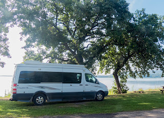
After a long day’s run, we got
the last campsite in the Aitkin town park. So we spent the night next to the
river. We hope we will be able to do that some more.
In Aitkin we had breakfast in a
popular local café/bakery. We try to eat in local places, rather than
franchises. That usually turns out to be good food and we get a sense of the
local culture.
This part of Minnesota is flat,
with huge fields of corn and soybeans. The road follows the river closely and
you get lots of views when the trees aren’t too thick. You can be 100 yards
from the river and the view will be completely blocked by heavy vegetation.
We spotted our first dam at
Sartell, just north of St. Cloud. It was put in for a paper mill, which may or may
not still be operating (there was no smell).
We decided that, being Sunday, this
was our best time to get through the Twin Cities; so we shortly got on I-94.
Before we got to the cities, we were trapped in a major traffic jam caused by a
wreck several miles ahead. It eventually broke up and the trip through the cities
was easy. We got to Wisconsin later than we expected, but managed to luck into
a good, riverside campground — where we again got the last available spot.
 |
| The view from the campsite (in light fog) |
In the morning we took a short
walk on the beach. Jean brought her binoculars and spent some time watching a
large raft of snow geese along the opposite shore of the bay.
We took care of several
necessary jobs, and got away just after noon. The road runs between a series of
bluffs and the river. We have arrived at the Driftless Region, an area that
somehow was missed by the great glaciers of the Ice Age. What few fields we saw
had corn and soybeans together.
In the afternoon, we came to our
first locks, Dam and Lock #4 in the tiny town of Alma., WI. Somehow we missed the
first three. We stopped and watched a huge towboat work through with a long
tow. The tugs on the Mississippi are called “towboats” even though they never
tow; they only push.
The raft of big barges was long
enough that they had to break it in half and lock through in two pieces. This
took quite some time.
Afterwards we had some lunch in a
bar across the street. After the rush to get through the Twin Cities, we are
consciously slowing down. So we often stop for the overlooks and to read some
of the historical markers. But we still got frustrated going through La Crosse.
Jean wanted to find a Wells Fargo bank, and she located the only one on her
phone. But both the map and directions were impossible to follow, so that didn’t
work out.
We got another campsite next to
the water on a backwater of the river in a county park where we had stayed
before. So far we are lucking out on campsites. Tomorrow we need to do some
shopping, then hope to finish the Wisconsin portion and go into Iowa. That will
allow us to color one more state on our little map.


No comments:
Post a Comment